Help plan the City of Canada Bay's future and steer decisions on issues that matter to you.
Share your feedback
Collaborate Canada Bay
Bay Run history
As you walk along the Bay Run several sites are marked with a sign. Each of the signs corresponds with a tab below, where you can find historical information and images about that location. Explore the tabs and learn about the area’s history as you walk along the track.
The Wangal People
Wangal Land — Custodians of Country
By Uncle Jimmy Smith, 2021
Warami. Bujari gamarruwa. (Hello. Good day.)
Welcome to Wanne country. This area, now known as the City of Canada Bay, has been occupied by Wangal People for at least 10,000 years. The Wangal People of the Eora nation (inner Sydney) belong to the Darug language group (greater Sydney Basin area), one of the dialects of the greater Sydney area. The Sydney languages and dialects, namely Eora, Dharawal and Darug have since been reconstructed from the many notes made of them by the original colonists, although there has been no known oral language tradition continuing over the last one hundred years. These languages have contributed to the evolution of contemporary Australian English with words like dingo, wallaby, wombat and waratah.
Wangal territory extended along the south side of the harbour from the western side of Iron Cove to Burramatta (Parramatta). The Hawthorn Canal is thought to signify the crossover of Wangal and Gadigal territories. Neighbouring Darug clans were the Wallumattagal on the northern shore of the Parramatta River and the Bediagal to the south.
The Wangal and neighbouring Gadigal and Burramatta clans were some of the First Peoples to be dispossessed of their territory as Europeans spread the colony up the Burramattagal (Parramatta River). This is why so much information about the original place names has been lost. Colonists co-opted significant Koori infrastructure, notably the utilisation of the ancient songline and trading route now known as Parramatta Road/Great Western Highway, which intersects with the upper reaches of Iron Cove Creek.
This Aboriginal infrastructure is still the framework for many roads across Australia, including another local transport artery, Great North Road. Numerous accounts exist attributing the name Go-mo-ra to the bays of Iron Cove. Some local place names still exist close to their original form, like Wareemba, while places like Bidjee Bidjee and Warayama have been renamed (Abbotsford and Cockatoo Island).
Nearby, significant places have names recorded in language, including Memel (Goat Island) and Booridiow-o-gule (Breakfast Point). Records indicate Memel and Warayama are extensions of Wangal Clan territory through Bennelong, an influential Eora man whose ancestral lineage is tied to these locations.
Booridiow-o-gule is recorded as the location of the first contact between Wangal People and Europeans. Implementing dual naming or the renaming of these places is an important aspect of reviving language, culture and cultural pride, while instilling First Nations peoples with a sense of belonging and reconnection to country. It is a powerful action to counter the common feelings of alienation and disconnection from ancestral lands (First Nations peoples are not the only ones benefiting from this enrichment).
This landscape provided everything in abundance including food, water, shelter and education. The shallow dyiral (shoal waters) and surrounding duga (brush/forest) contained pristine seafoods, lean meats, many birds, tuber vegetables, fruits, seeds, nuts, and grains. Badu (fresh water) from the creeks meets the salt water of the bays, with the expansive mangrove-lined tidal flats perfect for fishing. An innate understanding of the tidal workings of the bay allowed for a lifestyle structured around rich aquatic resources. Fish, eels, binyang (birds), gadyan (cockles), badangi (oysters), yara (crab), crustaceans and intertidal plants were feasted upon along the water’s edge, evidenced by the deep middens all over this landscape.
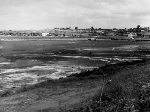
Timbrell Park, once an abundant wetland system and a teeming cornucopia of plant and animal life on the furthest southern reaches of the bay, was sadly filled in and replaced with a monoculture of grass. Unfortunately, colonial intervention continues to impede upon the once flourishing natural systems, causing many detrimental consequences for the lands and waters of Eora country (coastal Sydney). Bush regeneration efforts are now starting to return some of the land to its former glory. Records indicate this was a place of corroboree (gathering) and ceremony. The extensive middens that can still be found in the park also indicate prolonged and sustained occupation, especially alongside what is now known as Iron Cove Creek.
The reaches of baragula (flood tide) have been greatly reduced, cutting off the nourishment to this once diverse life source. With the spread of colonists, the land and waterways were drastically altered. Forests and wetlands were lost to concrete. Riverbanks and marine life were degraded by marrinuwi (big canoe, referencing colonist ships) with large powerful vessels like RiverCats still navigating Burramattagal (Parramatta River) day and night.
Before the concreting of the flood-prone waterway, Iron Cove Creek was a dazzling ecosystem of fresh, brackish and saltwater tidal pools. This ecosystem nurtured Aboriginal people (as they nurtured it), providing both abundance and education, with the natural world revered as the big classroom, the greatest teacher. It was a meeting place, a place of trade and interaction with other clans. Inter-tribal alliances and agreements across kinship groups allowed for seasonal or culturally significant movement across multiple territories, as well as trade, corroboree, ceremony and marriages. This could only happen with adherence to strict protocol when entering another's land.
Imagine yourself sitting under the guwing (sun), surrounded by forest, amongst scarlet warada (waratah). Refreshing yourself with waraburra, a sweet drink made from the crushed leaves of native sarsaparilla and badu (water). After collecting dinner in a gulima (basket), friends and family could gather around guwiyang (fire) to share knowledge and stories and to gunama (cook). They would roast yurungay (duck), burra (eel), magura (fish) and gurgi (bracken fern roots), all wrapped in gymea lily leaves, using a method that would produce delicious, smokey and tender meats and plants. People could baraya (sing) and dangura (dance), making yabun (music) with gamarada (friends), before heading gunya (home).
Wangal People would magari (fish) Burramattagal (Parramatta River) in a nawi (canoe made from sheets of bark bunched and tied at the ends and sealed with gum). Wangal women would sing fishing songs to lure their catches in, using bara (hooks made from shell, wood or stone) and garradjun, fishing lines made from spun barks such as kurrajong and gurrundurrung (paper bark). Wangal men would stand up in their nawis, using long gamai (spears) to catch fish, often under the glow of a marri yanada (full moon) and warrawal (Milky Way). Fish were often cooked fresh in the canoes upon beds of bamal (earth/sand/clay).
This abundant natural world provided plants with multitudes of uses. The red bark exudate of the Sydney Red Gum (Angophora Costata) was dissolved in warm water, and when cooled, the liquid was taken to relieve an upset stomach. Wood that had grown into a suitable shape was made into a coolamon that could be used to carry a variety of objects. The fresh gum of Eucalyptus camfieldii was collected, mixed with warm water, and applied to cuts and sores. Eel traps, mats and baskets were woven from Lomandra longifolia leaves. Suaeda australis (Seablite) would be eaten fresh, the edible leaves are pleasantly salty with a light, crunchy texture. Samphire is another edible succulent that grows on the bank of Burramattagal. Their slim, noded stems look similar to asparagus, but offer a salty, spicy taste.
It is imperative to the future health of Wangal lands that we all involve ourselves in the act of caring for country whenever possible. Sustained community efforts, like picking up litter, adding to our urban canopy wherever possible, providing possum boxes, bird boxes and getting involved in bush regeneration programs are ways we can work towards a better future for Wangal lands.
Click here fore more information about our original inhabiants.
Iron Cove Bridge and Birkenhead Point
Iron Cove Bridge
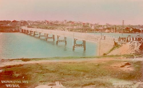
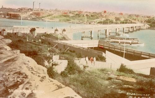
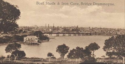
The original Iron Cove Bridge was opened in November 1882 and the sandstone abutments can still be seen on both ends. It was replaced by a new bridge to the northeast in July 1955. The spans from the 1882 bridge were reused for three bridges in the Forbes area of NSW. A supplementary bridge was built to the southwest of the 1955 bridge and opened in January 2011.
Birkenhead Point
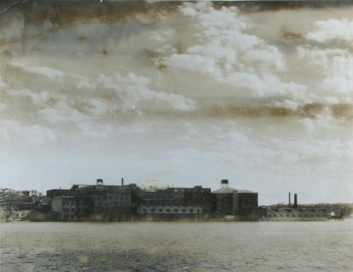
In the 1840s an enterprising Charles Abercrombie purchased land at present-day Birkenhead Point and established a ‘salting and boiling down’ works. However, this business eventually failed and the land was sold a number of times before being purchased by Henry Perdriau.
In 1885 Henry Perdriau began manufacturing rubber goods, opening an extensive plant at Birkenhead, as the area was known. By the late 1880s Perdriau & Co. were agents for overseas rubber companies and conducted an international trade in rubber goods.
In 1904 Perdriau Rubber Co. Ltd was founded and the company boomed, producing tyres when motor cars were introduced to Australia. In 1928-29 the company amalgamated with the Dunlop Rubber Co. of Australasia Ltd and Henry Perdriau became Director of Dunlop-Perdriau Rubber Co. Ltd. In 1941 the company’s name was changed to Dunlop Rubber Australia Ltd.
According to Saga of Sydney by Frank Clune (1961) the factory made "tyres, tubes, garden and industrial hose, battery cases, industrial goods and waterproof sheeting. The buildings have twelve acres (4.85 hectares) of ground space and… 1,600 workers on its payroll." Footwear, which was being made at the factory in the 1940s, had by that time moved to a separate factory at Bankstown.
In 1977 Dunlop ceased all operations at Birkenhead Point. The company relocated to Melbourne as the cost of redeveloping the badly outdated buildings was prohibitive.
After Dunlop left the site there were proposals to develop it as a large shopping centre. This lead to local protests and a call for Birkenhead Point to be designated open space. These protests were unsuccessful and the land was redeveloped as a major shopping mall which opened for trading in 1979.
Drummoyne Swimming Centre and Brett Park
Drummoyne Swimming Centre
Opened as Drummoyne Municipal Baths in November 1904, the pool replaced an earlier baths which had opened in 1899. The Drummoyne Swimming Centre is one of the oldest surviving Council pools in Sydney and the training ground for Olympians Dawn Fraser and Jon Henricks.
Brett Park
Brett Park was originally named Sisters Bay Reserve. It was renamed after Alderman Walter Henry Brett, who lived nearby, shortly after his death in May 1944. The Brett family was prominent in the sailmaking trade.
Sisters Bay
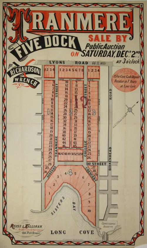
Sisters Bay is named after Sisters Rocks, a shoal probably now under the former Iron Cove Bridge abutment. The area was subdivided as the Tranmere Estate in 1882, part of the larger Bourketown estate.
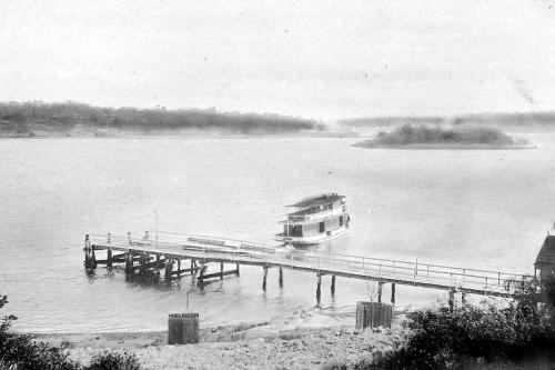
Thompson Street Jetty
Thompson Street Jetty
The Thompson Street Jetty was opened in early 1888 as a ferry wharf. In 1927 it was reconstructed as a jetty for the use of pleasure craft and that use has continued through a number of rebuilds until the present day.
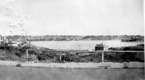
Half Moon Bay
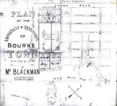
The name Half Moon Bay was in use in the early 1840s when the new township of Bourke Town on the west side of Iron Cove was promoted.
The Bourketown subdivision was developed on land known as Five Dock Farm. The land was owned by emancipist Samuel Lyons, bought from John Harris in 1836. Although first offered at auction in 1841 little development occurred in Bourke Town (as it was known originally) for more than five decades. In 1842 the level of land speculation and the accuracy of auctioneer statements were roundly criticised in the Sydney Morning Herald. Throughout the nineteenth century there were numerous attempts at promoting land sales and auctions for this subdivision but there were few sales.
Rodd Island and Henley Marine Drive
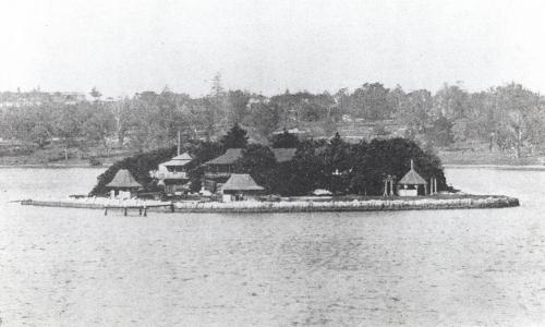
Rodd Island
Rodd Island was named after Brent Clements Rodd (1809–1898) whose house, Barnstaple Manor, stood where Princess Avenue runs between Noble Street and First Avenue in Rodd Point. Rodd Island was used by scientists sent by Louis Pasteur to investigate a way of eradicating rabbits in the 19th century. Since then it has been used as a recreation reserve and more recently was added to the Sydney Harbour National Park.
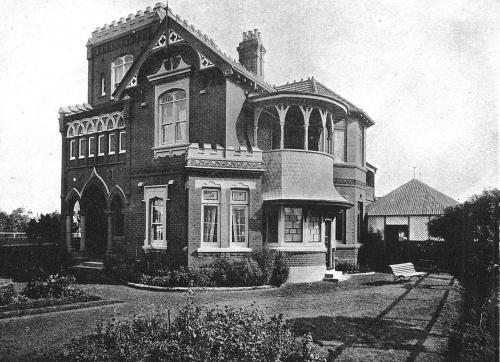
Henley Marine Drive
Construction of Henley Marine Drive, named after Sir Thomas Henley, commenced in 1910. Henley lived in Tudor House on 23 College Street (since demolished) and helped to form the new Municipality of Drummoyne, becoming its first Mayor in 1902.
Racecourse at Russell Lea
There is conjecture about the exact location of a racecourse that was developed at Dunmore Park (later named Woodsdown Park and then Russell Lea). The property was owned by William Abercrombie (possibly related to Charles Abercrombie).
The racecourse is said to be where the first steeplechase race in Australia was held, in 1844. The Five Dock Grand Steeple Chase had nine leaps, including a six-metre pond leap and a 1.4 metre stone fence.
The Sydney Morning Herald at the time declared that the "first race was regarded as the best that ever took place in the colony, and far exceeded the expectations of the most sanguine sportsmen present".
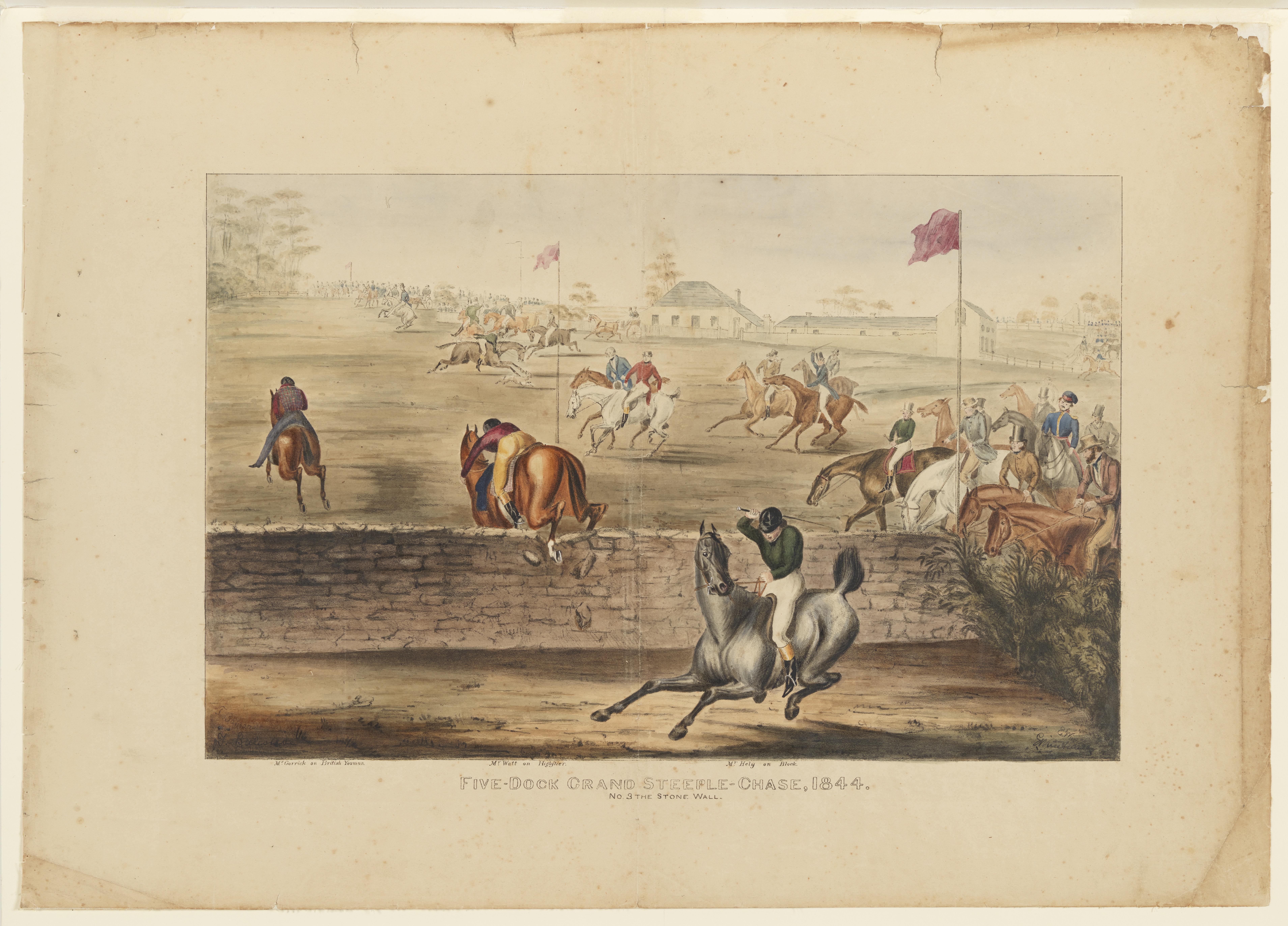
Five-Dock Grand Steeple-Chase - The Stone Wall 1844 / by Balcombe and Winstanley
Image courtesy of the collections of the State Library of NSW
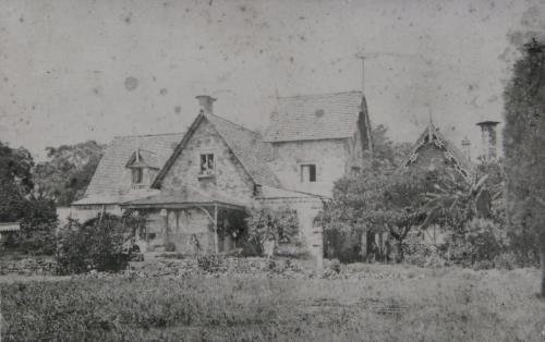
Rodd Point
Rodd Point was originally known as Vault Point, owing to the building of the Rodd family’s burial vault at the site. The Rodd family home, Barnstaple Manor, was designed by architect John Hilly and built in 1845. Unoccupied, the house was destroyed by fire in 1927.
Iron Creek
Iron Creek appeared on maps as early as 1810. It is not known if the name was taken from Ironbark Eucalypts that grew in the area or the ironstone that was quarried nearby. In the 1940s, Drummoyne Municipal Council began a land reclamation program. This area was extensively filled, with Timbrell Park built mostly on reclaimed saltmarsh and mangrove swamp.